The efficiency of using the 100-year floodplain as a metric for determining flood risk is being studied by Texas A&M urban planning researchers.
Study: 100-year flood plain poor indicator of likely flood damage

Samuel Brody

Michael Lindell

Wesley Highfield
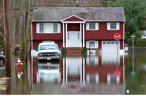
The 100-year floodplain, a longstanding metric for determining the chance of an area’s inundation by flood waters, appears to be an inaccurate measure for predicting potential flood-related loss, said Samuel Brody, professor of urban planning at Texas A&M.
Brody, also director of the Center for Sustainable Coastal Communities at Texas A&M University at Galveston, is heading a two-year, $313,000 National Science Foundation-funded study examining the effectiveness of using 100-year floodplains to predict property damage from floods.
Misperceptions about the 100-year designation give property owners a false sense of security, said Brody, and make it more difficult to manage community development in a resilient manner.
The Texas A&M study, he said, "will provide policymakers and localities with improved criteria for assessing flood risk in low lying coastal areas to better protect against loss of property and lives."
The study's review of 1999 – 2009 flood loss data from sampled coastal counties along the Gulf of Mexico showed that approximately half of the insured flood claims originated from damage occurring outside of the 100-year flood plain, and on average, that damage occurred approximately 1,067 feet beyond the plain boundary.
While low-density developments with parking lots or similar large, impermeable surfaces sustained significantly increased flood losses, Brody said flood damage was reduced in areas where the environment is embedded into the development.
In addition to reviewing historical flood-related statistics, researchers have employed nontraditional techniques in their analysis of flood damage prediction models. They are using proximity and built environment data to determine floodplain boundaries while controlling for hydrological and socioeconomic variables.
To better understand the perceptions of flood risks and residents' motivations for mitigating potential adverse impacts, the study includes a representative survey of households that claimed insurance losses from both in and out of the floodplain.
“This research will not only ascertain the effectiveness of the 100-year floodplain in predicting observed damage and human response, but will also generate results that will lead to more precise risk analysis in rapidly developing coastal areas,” explains the study abstract.
Brody said the findings will be packaged in an accessible, easy-to-understand format for use by public officials and coastal residents as well as by households that may be outside the floodplain but still at high risk for flood losses.
Data from the study will be incorporated into the [Texas Coastal Communities Planning Atlas] (http://coastalatlas.tamug.edu/atlas.htm) , a website enabling users to identify and visualize information on flood risk in their neighborhoods.
The research team also plans to deliver information — through partnerships with neighborhood associations and other stakeholder groups — to residents of vulnerable neighborhoods, including traditionally underrepresented groups that do not have easy access to flood risk information.
Brody, holder of the George P. Mitchell ’40 Chair in Sustainable Coasts in the Department of Marine Sciences at Texas A&M-Galveston, is conducting the study with fellow researchers Michael Lindell, professor of urban planning at Texas A&M University, and Wesley Highfield, assistant marine science professor at Texas A&M University at Galveston.
Tags
- coastal systems
- environment
- hazard
- hazard reduction & recovery
- honors
- landscape architecture & urban planning
- planning
- research
- sustainability
Related Posts

HRRC examining implementation of local hazard plans
Nation's safety enhanced by resiliency studies

Mapping at-risk populations aids hazard mitigation

Prof suggests ways to enhance community hurricane resilience

Study eyes how lower Lake Conroe levels impact economy
Follow Us
Facebook Twitter Vimeo Youtube Flickr RSS
Recent Posts


Planning prof heads study of disaster housing aid

A message from the dean


_thumbnail_small.png)

Former student remembered as expert planner


Leading educator named new head of Architecture Dept.
