


D-Day Ranger monument saved by Aggie-led restoration effort
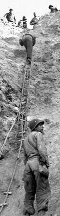
Rudder's Rangers scale cliffs at Point du Hoc on D-Day, June 6, 1944.
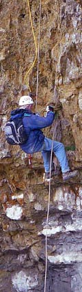
Professor Bob Warden rappels down Pointe du Hoc cliffs during 2008 research trip.
Visitors to the historic D-Day battlefield at Pointe du Hoc in Normandy, France can once again visit the cliffside monument honoring the heroism of U.S. Army Rangers who served under the command of future Texas A&M president Earl Rudder.
Deemed unstable and closed to the public since 2001, the precariously perched memorial reopened last year after a $6 million site restoration informed by research gathered by faculty and students from the university’s Center for Heritage Conservation.
On June 6, 1944, “Rudder’s Rangers” performed one of the war's [greatest feats] (http://media.oaktreesys.com/abmc/pointeduhoc/popup.html) , scaling Pointe du Hoc's 90-foot cliffs under intense German gunfire and securing the site as part of the famous Allied victory.
Lt. Col. Rudder later served as Texas A&M president from 1959 until his death in 1970.
Before the site’s restoration, the monument was in danger of collapsing into the English Channel due to erosion of the Pointe du Hoc cliffs from rainwater, high winds and the constant pounding of waves.
To save the memorial, a Texas A&M research team led by Robert Warden, CHC director and professor of architecture, Jean-Louis Briaud, professor of civil engineering, and Mark Everett, professor of geology and geophysics, made several trips to the battlefield to gather data that was later used by engineers to stabilize the cliffs and rescue the endangered structure.
Made safe, the Ranger Memorial was rededicated at a June 6, 2011 ceremony attended by Rudder family members, more than 40 D-Day veterans, current and former members of Congress, and other dignitaries.
High-tech investigation
The CHC research team, which also included a number of Texas A&M students, initially mapped the site and sub-surface using state-of-the-art 3-D imaging tools and took core samples from the ground.
To survey the site, Warden used a total station, a tool that employs a laser to measure angles and distances to specific points on a structure or geological formation. The coordinates are transferred to a computer to produce 2-D maps and 3-D models of the surveyed area using AutoCAD, a computer-aided design program.
To enhance the accuracy and precision of the total station measurements, the team used photogrammetric equipment including cameras, scanners, computers, specialized software and plotters.
Groundwater and caverns located beneath the battlefield were revealed in an electrical resistivity tomography study conducted by Everett. A technique for imaging sub-surface structures, ERT uses variations in electrical currents to measure mass and density of underground geology. Core samples drilled from the battlefield were analyzed to determine the soil’s strength.
Ultimately, the investigators determined that a series of caverns honeycombing the cliff rocks were undermining the memorial site’s structural integrity.
"There is no doubt in our mind that the single most important part of any remediation of the cliff erosion is to backfill the caverns at the cliff base," wrote Briaud, with Hamid Reza Nouri and Colin Darby, civil engineering graduate students on the CHC team, in the study's final report.
Erosion from rainwater formed the caverns, said Warden. "In a nutshell, rainwater dissolves the limestone, which forms caverns and loosens rocks. Then you have the mechanical action of the sea that pulls big stones out. When a cavern gets big enough," he continued, "the cliff fails."
Research informs the solution
Based on the Texas A&M team's findings, consultants recommended placing micropiles, or concrete columns, 130 feet into the bedrock underneath the observation post to stabilize it. A French company, the GTS Group, began the $6 million project, funded by the American Battle Monument Commission, in February 2010 ( [project plan] (http://www.abmc.gov/Pointe_du_Hoc_Project_Presentation_light.pdf) 1.7 MB PDF). The ABMC maintains U.S. military monuments and markers in foreign countries.
The project was tackled in four phases:
- Filling caverns at bottom of the cliffs with concrete;
- Nailing the sides of the cliffs into place with metal bars measuring up to 26 feet long;
- Reinforcing the land surrounding the memorial; and
- Stabilizing the ground underneath the memorial by driving a "safety belt" of vertical metallic tubes 10 inches wide and 78 feet deep, into the ground around the front of the memorial, which was temporarily removed for the work.
GTS also installed equipment that will measure geological and hydrological information at the site for several years.
Congress funds investigation
The plight of the ranger memorial was initially identified by Texas A&M researchers in 2004, when a team from the College of Architecture’s Historic Resources Imaging Laboratory, which later became the CHC, began documenting the site to gain a better understanding of the historic battle in a study funded by the National Center for Preservation Technology.
David Woodcock, then a professor of architecture at Texas A&M and the director of the HRIL, brought the critical problem to the attention of U.S. Rep. Chet Edwards in 2006. The congressman initially secured a $434,000 grant to the ABMC to expand the Pointe du Hoc study and determine the causes of the cliff’s instability.
With Edwards’ recommendation, as well as support from the U.S. Army Rangers and the Rudder family, the ABMC selected the CHC team to conduct the study.
After the team presented its initial findings to the ABMC, recommending a follow-up study focused on the erosion’s effects on the observation post and Ranger memorial, Edwards came through again in 2008, garnering an additional $361,000 for the project.
It was this investigation that uncovered the expanding network of caverns, the need to fill them and shore up the cliff face.
Researchers battled the elements
Though no enemy with lethal force awaited them at the Pointe Du Hoc site, on their final field trip CHC researchers did have to battle the Normandy coast's wintry weather and treacherous terrain.
“It was cold, around 40-45 degrees, rainy and windy, with winds blowing from 40-60 miles an hour all the time,” said Warden. “We had a couple of decent days to work with, but for the most part it was a lot of wind and a lot of rain. We had to go through some extraordinary measures to make sure we got our data.”
The only way to get to the beach, he said, was to rappel down the cliff with equipment, which took about two-and-a-half-hours each day, said Warden.
“We would usually start a couple of hours after high tide, when there’s enough beach exposed so we could get ourselves and everything down there — the total station, scanner, tripods, car batteries, backpack of tools, a camera — we needed it all in order for it to work. If you forget something, you can’t just go back and get it.”
Landing on the Pointe du Hoc beach isn’t really a day at the beach either.
“It’s not a sandy beach; it’s covered by huge boulders. It’s very slippery too, because the boulders have seaweed and moss growing over them,” said Warden. “It’s dangerous to walk on without even carrying anything, but getting equipment from one position to another was one of the more challenging parts of the whole process.”
Congressman praises Texas A&M team's effort
Edwards lauded the effort to restore the monument at an Oct. 20, 2010 press conference at Texas A&M’s Langford Architecture Center during which he announced the planned reopening of the memorial.
“Once again the people of the world will be able to visit this historic site and its monument dedicated to Lt. Colonel Earl Rudder and the U.S. Army’s 2nd Battalion Rangers,” Edwards said. "People … will be able to understand America's leadership in saving the world from the tyranny of Adolf Hitler."
Edwards also acknowledged the efforts of CHC researchers.
"Let me thank Dr. Warden and everyone here at Texas A&M University who literally planted the seeds for this important mission to save Pointe du Hoc," he said, "for all future generations to see and be reminded of what was done there."
An interactive multimedia narrative of the historic battle at Pointe du Hoc, which was characterized by Allied Forces as “the single German Defense position most dangerous to their invasion plans,” is available on the American Battle Monuments Commission's [website] (http://media.oaktreesys.com/abmc/pointeduhoc/popup.html) .
Tags
- architecture
- chc gallery
- global college
- graduate work
- heritage conservation
- history
- interdisciplinary
- outreach
- research
- sustainability
- video
Related Posts

CHC documenting historical sites in Belize, Texas, Calif.
Grad students seek long term refugee housing solutions

Acropolis research reveals ancient site’s social history

Arch prof helping restore original hues of Bermuda houses

Arch profs studying distinctive baptismal font canopy
Follow Us
Facebook Twitter Vimeo Youtube Flickr RSS
Recent Posts


Planning prof heads study of disaster housing aid

A message from the dean


_thumbnail_small.png)

Former student remembered as expert planner


Leading educator named new head of Architecture Dept.
